
Ghosts Of The Horn!

Many of those who will read this and who have read the few that I wrote before are justified in wondering why any Eritrean in his/her right mind would be skipping all the catastrophes that Eritreans are facing and be fixated with unsexy, irrelevant and off-date issues. There are a lot of Eritreans who are facing death and pain in the hands of dictators, jailers, traffickers and by everyone who can inflict pain almost everywhere. There are a lot of Eritreans doing their utmost to free prisoners, support victims and ease the pain of millions. Why ignore all this and go only for what adds pain and torture to our already exhausted spirit? My conviction is that what we see on the ground in terms of places and people being squeezed and crushed are the fault-lines of the tectonics that we need to watch and unless we keep debating the bigger picture and finding solutions that can work; our struggles will be lost in the details and symptoms. Our political opposition is seriously at risk of being taken over by humanitarian activism. Critical as that component of the struggle is – we need to turn back and start changing things on the ground!
Disclaimer: The following may look scientific because it has maps and tables with numbers. It has nothing to do with science and is not intended to make any claim or implication of statistical evidence. They are just numbers gathered from the most unscientific sources in the internet and in coffee-shop gossip places. The best you can do is to read the whole thing – think about its implications – avoid responding or commenting on the credibility of the data. I am telling you it is not credible. Don’t get into the trap: if you get the controversy to be about whether the numbers are accurate or not then it would imply that you have at least agreed on the principle of the validity of squeezing population statistics for clues. If you actually believe that you can guess the phone numbers of bad people by playing around the numbers in population statistics, then I challenge anyone to repeat the calculations with actual accurate numbers drawn from the most reliable sources to produce a different picture.
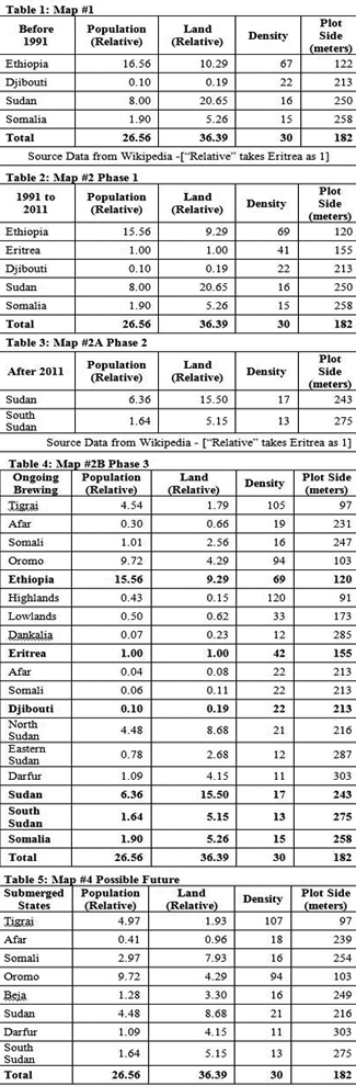
The data was taken from Wikipedia and is all suspect, made up or reengineered by me personally to fit a hidden agenda. It is relative population Vs land area statistics referring to the countries of the Horn of Africa defined to include only the countries shown in Map #1 below. The numbers are not consistent across tables and may not match reality exactly (in fact some populations may be off by a few million individuals) but they are the closest it can get to plausible gossip, when as we have done here constant ratios are used. Off by a few million?! Yes. Consider them lost in action during calculation – casualties of the next war – or victims of some upcoming catastrophe. The idea is based on a static situation of one point in time rather than a more telling dynamic scenario that would have considered population growth rates.
This is supposed to be for serious discussion. That is why I am not including anything that is colorful or inflammatory or controversial. The intention is to develop one of many possible scenarios for the future as independent states in the Horn of Africa (in one or several pieces each). I do understand the well-justified sensitivity and potential dangers embedded in the reproduction of such maps. My hope here is that people read the maps proactively and employ their genius in reengineering the region back to unity. I will try to make it short by just describing what each of the five maps stands for and how they are related to each other. You won’t miss anything if you just study the maps in their sequence and skip the text and data of this article altogether.
Map 1: Colonial Legacy
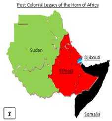 Formally, the national boundaries shown in Map #1 were in effect until 1991 (about 22 years ago). Until then, Sudan was about 20 times bigger than Eritrea, Ethiopia was 10 times bigger, Somalia was 5 times, and Djibouti was just a fifth of Eritrea. Ethiopia had the highest population density with more than 60 persons per square kilometers. If we assume that the people of Ethiopia were equally distributed such that there was exactly the average density per square kilometer, then each sq km would have to be split to a plot of a little more than 122 meters by 122 meters per individual. In Sudan the plot size per individual would be about four times that of Ethiopia, in Somalia even better and in Djibouti too. Ethiopia was the worst place to dream of owning land.
But that is not how it works. Large portions of all countries are not of much use and in places such as Abyssinia there is a big chance that your assigned plot might land on a solid piece of bald rock. There are also the risks of sharing the plot with squirrels, snakes, lizards and bad luck. That’s to say your share is much smaller than the 122 by 122. But that shouldn’t be a concern at all because some European countries have much smaller plots per person and they are doing just fine. The difference is that in a developing country where more than three quarters of the populations are farmers, the value of land as such becomes persistently annoying for state administration. It is very likely that three quarters of the individuals in all the countries of the region will think of their plots in terms of arability. Compare the last column of Table 1 and imagine.
Map #2A: Independent Countries
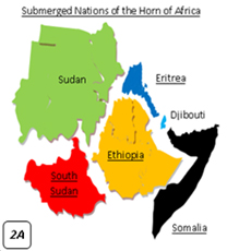 In 1991 Eritrea split from Ethiopia and twenty years later South Sudan split from the North. The numbers of densities and therefore plot sizes changed accordingly. Both Ethiopians (Setit-Mlash) and Northern Sudanese got squeezed just a bit and plot sizes per person became smaller in both. Eritreans could feel the difference in a few years of post-independence honeymoon and started dreaming. They ended up with much larger plots per person at around 155 by 155 meters at the expense of all Ethiopians losing a little bit. If plot size was the only determinant of the winds of change (i.e. ignoring all other factors that pushed the demand for self-determination), then Eritreans were rational in demanding change.
Table 2 shows the period between Eritrea’s independence before South Sudan’s split from the North and Table 3 only modifies for South Sudan as shown in Map #2A. The dimension of an average Sudanese plot size fell from 250 meters to 243 and Southern Sudanese increase to 275 by 275 meters. Conclusion: Southern Sudanese were rational when they demanded independence.
Map # 2B: Submerged Identities
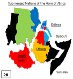 If we look a little deeper into what happened within those independent states or the trendy fault-line politics in each of those countries we will have an idea of the Ghosts of the Horn wiggling their way out into the open. The colors don’t mean anything as they were picked randomly. As you know fault-line politics in Eritrea is played along the Lowland-Highland-Dankalia divide. Here fault-line politics is not about painting chunks of nations on the basis of “eye-color classification”. These colored fault-lines are actually represented by a heavy presence of armed political organizations, numerous revisionists rewriting history, and millions of bigots.
According to my argument in this article, these fault-lines are dreams fueled by the rational calculation of the prospects of maximizing plot sizes per person on the ground. Of course the larger the relative plot sizes, the more promising the alternative (splitting rather than staying). Like I said before, these aren’t imaginary ghosts. They are real and most of them carry arms and have been into it for years and they actually think the countdown to that day had started years ago. Two of them, Eritrea and South Sudan have already achieved the first stage of their goal and who knows what the next stage will be. If you look into the map of Eritrea with special focus on the deep blue color you will know what the first stage was.
The Eritrean revolution as you know officially started with the first trigger of Hamid Idris Awate in the Lowlands of Eritrea. Allow me to be as dumb as Qernelios Osman for a moment: No one really knows what Awate’s original idea was because he never lived long enough to tell his side of the story. I have no doubt he was the absolute hero of our struggle and our unifying symbol today. Personally, I have never heard of any public statement that he ever made or any position that he ever took on any relevant issue other than what we have been told. What are elaborately described in our history books are what the highly opinionated intellectuals around him thought or decided the goals were.
Even these descriptions weren’t constant throughout our history as you know and there was no consistency between words and deeds (i.e. declared and actual goals). We all wonder how, ten years after progress in achieving those goals, some people discovered that the ELF’s goal was very different from what they had thought it to be and opted for a split into a brand new organization called the EPLF. You can see the same realization in today’s Unionist Eritrean writers and politicians. While the politicians of the 1940s voted sensibly (according to fault-line politics motivated by the prospects of maximizing plot-sizes) in favor of union with Ethiopia, the new generation in the 1960s & 70s voted for the opposite goal. What independence unambiguously produced was a complete split of the western lowlands from Ethiopia together with partial independence in the highlands and Dankalia. Here “partial independence” essentially means a situation with a high degree of likelihood for revision to take care of unfinished business.
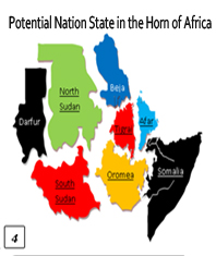
Map #3: Ghost States
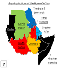 As you can see in Ethiopia, the Tigrai (I have included Amhara and anything in between in the classification) would have the smallest standard plot size in case of fragmentation. The Oromo look the second but this is probably because I have included everything that inhabits their region (and many are not Oromo) in the numbers. According to the formula (of rational fault-lines) the Somalis should have been the first to set on demolishing the union (and in fact they were among the first to try), the Afar should be the next to kick out.
In Eritrea the picture is identical. Plot sizes in the lowlands look smaller than they should be because (like the Oromo) I have included everything that inhabits the region in the numbers (I have also included all tiny ethnic groups into the classification). The formula again: the first to demolish the union should be the Afar followed by the Lowlands. Djibouti is too tiny to have a say on the region so I just took the liberty to split it almost into two between the Afar and Somalis. Somalia as you know is a mess. I left it as it is. In Sudan, however, you split the nation my formula does not seem to work as land is abundant everywhere. Although Darfur and Eastern Sudan do seem to have a marginally higher incentive to split, I doubt Northerners would try to keep them for their land. But we are not far from the truth as Darfur as you know is only a matter of time before it is gone. Eastern Sudan is no different than Somalia with more tribal complications within the region and too much politics.
If you take a broader view and think in terms of the whole region as a unit instead of taking the restrictive colonial boundaries of the various countries, we may factor-in the possibility of reinforcing identities and politics across borders. That would probably end up into a more connected ethno-region with at least eight Ghosts of the Horn of Africa. Please do not consider any of these maps, figures or words as a wish-list of things to do. I am terribly scared that this crazy scenario might happen but even to evade it we need to know what it is and its probabilities of coming true.
Map 4: The Future Horn
 Having established my intention to do a great service to our national unity, imagine a situation whereby the Ghost states achieve political independence from one another. I am not promoting the idea that these eight independent states will be heaven or will have fewer problems than they do. There is credible evidence that each of them will turn into a nightmare. We already have Somalia and South Sudan and even Eritrea where people’s wish-lists have changed substantially. I definitely wish nothing had happened in Eritrea.
From your own experience with the Eritrean revolution I am sure you know that, that is not how things work. The strongest magic of revolution and its darkest secret is that you will never find out that you have been duped until you are actually duped. Would you have listened to anyone who would tell you that you would be worse off after Eritrea’s split from Ethiopia during the Eritrean revolution (1961 to 1991)? When did you start to listen and wish you had paid attention to people like Yosief Gebrehiwet and others like him? When did they themselves find out they were duped? After walking a million miles of thorns and landing on the hot spot?!
Now imagine someone telling these same people about the numbers in Table 5. The numbers are derived by collecting like terms from Table 4. Skip South Sudan because some guys have already done it before you. Skip Darfur because it is already under way and inches for the bitter truth to come out. Forget the Somalis who if it weren’t for geopolitics of the Cold War, would have done it decades ago. Let the PFDJ stay in power for a few more years and transnational Tigrai-Tigrigna is fully institutionalized. Give the Afar and the Beja some time to go transnational from an organizational point of view and you are done.
Conclusion
My hope is that we all become sensible enough to swim with the current rather than against it. Unfortunately, the trend as you can see is this: we had four countries less than a quarter of a century ago and now we have six full blown internationally recognized states. The rest of the colors are in progress and you either know what I am talking about or you are a member of one of those organizations that are doing what the EPLF and SPLA used to do and are marching towards what they are doing today. Personally, I have no doubt that is where things will eventually end up. Core of the Problem: where population density (relative plot size) becomes an incentive to fight tooth and nail to maintain the status quo is in what I have labeled as greater Tigrai. Sudan lacks this essential incentive and therefore the likelihood of viewing a split as a matter of life and death should be very marginal. Northern Sudanese may fight of course but they won’t have a problem to give up like they did in South Sudan.
We can mention four factors that may count as points of strength for this project: (1) it is more democratic than what we have as increasing one’s share of the country should (at least symbolically) increase one’s relative voting power (intensity) and can therefore be packaged marketed attractively; (2) the resultant map of the Horn of Africa would be composed of relatively more equal states in terms of size and the project should therefore offer a more attractive alternative of peaceful balance for a historically turbulent region; (3) transnational links created by shared concerns of refugees and dictatorships in an increasingly interdependent borders infested with insurgencies, smuggling (trafficking) routes and the rise of ethnic entrepreneurship is laying foundations for the necessary infrastructure; and (4) within the broader regional geopolitics the project coincides with the attempts of regional actors to transform the Red Sea into an “Arab-Islamic lake”.
Let us pray that nothing of the above actually takes place and let me see what you think as we will be visiting the maps in more details.

Awate Forum